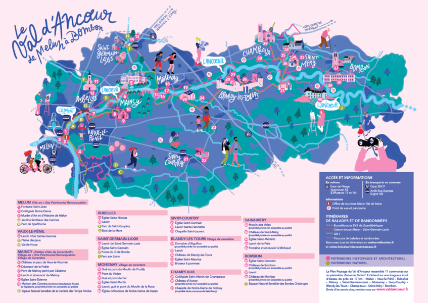
The Val d'Ancoeur : a protected site
The history begins like a fairy tale : "Once upon a time the Val d'Ancoeur..." with its castles, its legends and the 3 names of this small stream, which has become a myth, that from Ancoeur becomes Ancoeuil to end as the Almont... before flowing into the Seine.
(Extract from the website of the Departmental Archives)
The Ancoeur stream is a watercourse that has its source in the municipality of Grandpuits-Bailly-Carrois at an altitude of 125 m. It then takes the name of "Ancoeuil" in the municipality of Moisenay and joins, after a journey of 25 km from its source, the Bassin de la Poële of the Vaux-le-Vicomte castle. At the exit of this basin, it flows into the "Almont" 5 km downstream into the Seine at Melun. It constitutes, with its tributaries, a catchment area of approximately 306 km².
The Ancoeur stream flows through the municipalities of Grandpuits-Bailly-Carrois, La Chapelle-Gauthier, Bréau, Bombon, Saint-Méry, Blandy-les-Tours, Moisenay, Maincy and Melun.
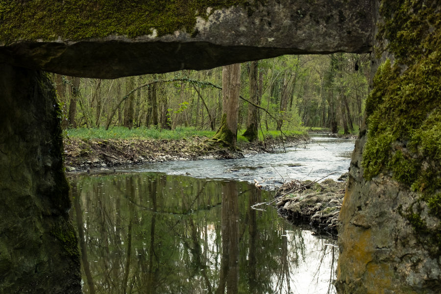
Classified as an "Exceptional Site" since October 14, 1985 by the Regional and Inter-Departmental Directorate for the Environment and Energy of Île-de-France, the Ancoeur stream offers enchanting landscapes. The classified site covers 1,861 hectares.
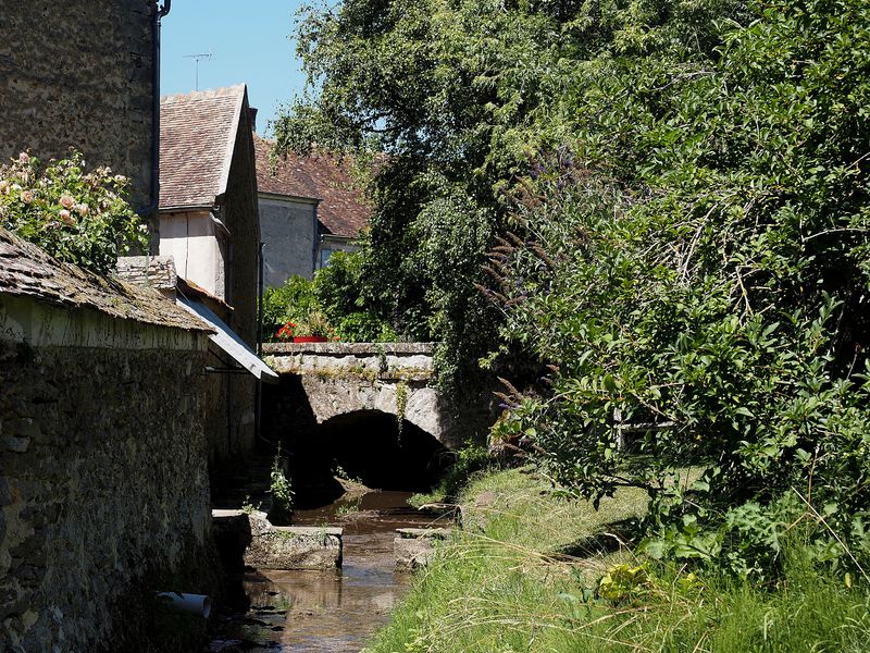
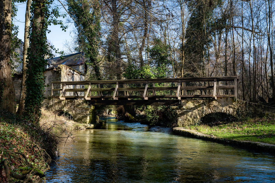
Along the watercourses — the Almont, the Ancoeuil (or Ancueil) and then the Ancoeur — the Val d'Ancoeur unfolds its panoramas : villages, forests, castles (Vaux-le-Vicomte, Blandy-Les-Tours...) but also, at the confluence of the Seine, urbanised areas.
"The Ancoeur is a very low-flow river, highly irregular and regularly at risk of running dry. The annual runoff depth within its catchment area is 96 millimeters annually, which is among the lowest in France, more than three times below the national average, and above all well below the average for the entire Seine basin (approximately 240 millimeters). The constant flow of the Ancoeur has, however, for centuries made it possible to operate the many mills. The large number of hydraulic structures, such as canals, basins and ponds, small reservoirs and mills, give the landscape a particular identity centred on water and its management. This is to be understood in relation to the wet character of the land."
A place of life, production and creation, the Val d'Ancoeur brings together major heritage sites across the entire territory : churches and works of art dating back to the 12th century, castles, farms, mills, rural dwellings, small rural heritage...
It has also become a subject of reflection and aesthetic admiration thanks to the artists who have captured its beauty and interpreted it in their own way.
- The Ancueil ("Anqueil" in its 17th-century spelling) gave its name for example to a majestic statue in the park of Vaux-le-Vicomte, located to the left of all the grottos (1659–1662), facing the Tibre installed to the right in 1659.
- The painter Paul Cézanne immortalised the bridge called Pont de Maincy in 1879 (now held at the Musée d'Orsay).
- And the sculptor Auguste Rodin dedicated magnificent drawings to the collegiate church of Champeaux (1890–1917), as testimony to his admiration.
For several years, the Communauté de Communes Brie des Rivières et Châteaux and the Communauté d'Agglomération Melun Val de Seine have joined forces to develop a Landscape Plan, revealing the assets of the Val d'Ancoeur. An opportunity for the protection and enhancement of the landscape heritage. The perimeter, which is based on the classified site, encompasses 11 municipalities across an area of approximately 56 km². It extends over a straight-line distance of nearly 17 km.
The Ancoeur stream is a watercourse that has its source in the municipality of Grandpuits-Bailly-Carrois at an altitude of 125 m. It then takes the name of "Ancoeuil" in the municipality of Moisenay and joins, after a journey of 25 km from its source, the Bassin de la Poële of the Vaux-le-Vicomte castle. At the exit of this basin, it flows into the "Almont" 5 km downstream into the Seine at Melun. It constitutes, with its tributaries, a catchment area of approximately 306 km².
The Ancoeur stream flows through the municipalities of Grandpuits-Bailly-Carrois, La Chapelle-Gauthier, Bréau, Bombon, Saint-Méry, Blandy-les-Tours, Moisenay, Maincy and Melun.
Classified as an "Exceptional Site" since October 14, 1985 by the Regional and Inter-Departmental Directorate for the Environment and Energy of Île-de-France, the Ancoeur stream offers enchanting landscapes. The classified site covers 1,861 hectares.
Along the watercourses — the Almont, the Ancoeuil (or Ancueil) and then the Ancoeur — the Val d'Ancoeur unfolds its panoramas : villages, forests, castles (Vaux-le-Vicomte, Blandy-Les-Tours...) but also, at the confluence of the Seine, urbanised areas.
"The Ancoeur is a very low-flow river, highly irregular and regularly at risk of running dry. The annual runoff depth within its catchment area is 96 millimeters annually, which is among the lowest in France, more than three times below the national average, and above all well below the average for the entire Seine basin (approximately 240 millimeters). The constant flow of the Ancoeur has, however, for centuries made it possible to operate the many mills. The large number of hydraulic structures, such as canals, basins and ponds, small reservoirs and mills, give the landscape a particular identity centred on water and its management. This is to be understood in relation to the wet character of the land."
A place of life, production and creation, the Val d'Ancoeur brings together major heritage sites across the entire territory : churches and works of art dating back to the 12th century, castles, farms, mills, rural dwellings, small rural heritage...
It has also become a subject of reflection and aesthetic admiration thanks to the artists who have captured its beauty and interpreted it in their own way.
- The Ancueil ("Anqueil" in its 17th-century spelling) gave its name for example to a majestic statue in the park of Vaux-le-Vicomte, located to the left of all the grottos (1659–1662), facing the Tibre installed to the right in 1659.
- The painter Paul Cézanne immortalised the bridge called Pont de Maincy in 1879 (now held at the Musée d'Orsay).
- And the sculptor Auguste Rodin dedicated magnificent drawings to the collegiate church of Champeaux (1890–1917), as testimony to his admiration.
For several years, the Communauté de Communes Brie des Rivières et Châteaux and the Communauté d'Agglomération Melun Val de Seine have joined forces to develop a Landscape Plan, revealing the assets of the Val d'Ancoeur. An opportunity for the protection and enhancement of the landscape heritage. The perimeter, which is based on the classified site, encompasses 11 municipalities across an area of approximately 56 km². It extends over a straight-line distance of nearly 17 km.
Tarifs
Free access.
Prestations, conforts et services
- Langues parlées :
- French
Périodes d'ouverture
All year round daily.